Sussex-Lisbon Area’s Pre-History
(For further reading click The Story Of Wisconsin, 1634-1848)
Compiled and Edited by Michael R. Reilly
Last Revised 10/07/2011
The Sussex-Lisbon area was once part of New France, which was the western 2/3’s of North America claimed by France in 1671, and then the Northwest Territory in 1783 (but wasn’t yielded by British troops until 1815). The Northwest Territory originally consisted of the future states of Ohio, Indiana, Illinois, Michigan, and Wisconsin. Ohio achieved statehood and left the Territory; then in 1796 it became part of Wayne County (Detroit) (Editor’s note: Detroit was part of the “Indiana Territory” with Fort Dearborn or later on, Chicago, being the closest settlement). Then Indiana (became a state) left and it was controlled from Illinois’s Fort Dearborn (Chicago). In 1818 it was part of Brown County (Green Bay), created by the Governor of the Michigan Territory (Brown County being one of three counties created). And just whensettlers came into the area, it became part of Milwaukee County in May, 1834 when it separated from Brown County. See more details below by year. Also see 1836
Wisconsin was explored bythe French from bases in Canada. Jean Nicollet visited eastern Wisconsin in1534. A fuller expedition was conducted by traders Radisson and Groseilliers(1658-1659) Father Allouez established a mission near the present Green Bay in1665. The first permanent settlement was made near the same area in 1670. Theentire state was a part of New France until the French were defeated in 1763.The sympathies of the settlers were primarily to the British, and retained theirallegiance during the Revolutionary War.
1763 – Wisconsin was part of the territoryceded by France to Great Britain in the Treaty of Paris.
1774/October 7 – Wisconsin Becomes Part of Quebec
On this date Britain passed the Quebec Act, making Wisconsin part of the province of Quebec. Enacted by George III, the act restored the French form of civil law to the region. The Thirteen Colonies considered the Quebec Act as one of the “Intolerable Acts,” as it nullified Western claims of the coast colonies by extending the boundaries of the province of Quebec to the Ohio River on the south and to the Mississippi River on the west.
1780/September 6 – the Congress of theUnited States asked the several states having claims to waste and unappropriatedlands in the western country to make a cession to the United States for thebenefit of the Union. In a deed signed on March 1, 1784 and modified on December30, 1788, The State of Virginia yielded to the United States her claim to thearea northwest of the Ohio River with the stipulation that it be formed intodistinct states. For the purpose of temporary government The Northwest Territorycame into being in 1787. Five states were carved from this territory: Ohio,Indiana, Illinois, Michigan and Wisconsin.
1783 – Acquired by treaty from Great Britain:Lands North of River Ohio, bordered on the West by the Mississippi River, with aNorthern boundary starting at Lake of the Woods in the Northwest (NortheastMinnesota) continuing East through the center points of Lakes Superior, Huron,Erie and Ontario.
1785 – Massachusetts relinquishes claims toSouthern portions of Wisconsin. Another source – After the Revolutionary War,Virginia ceded the area to the United States. (Note: Various eastern states hadmade overlapping claims to this area.)
1787 – Under the Northwest Ordinance, “Northwest Territory” organizedfrom areas of Wisconsin, Michigan, Illinois, Indiana, majority of Ohio, andNortheast Minnesota.
1800 – Indiana Territory organized from NorthwestTerritory, taking Wisconsin, Illinois, Indiana, Northeast Minnesota and Westhalf of Michigan. “New” Northwest Territory made up of Ohio and Easthalf of Michigan.
1805/January 11 – It became a part of MichiganTerritory.
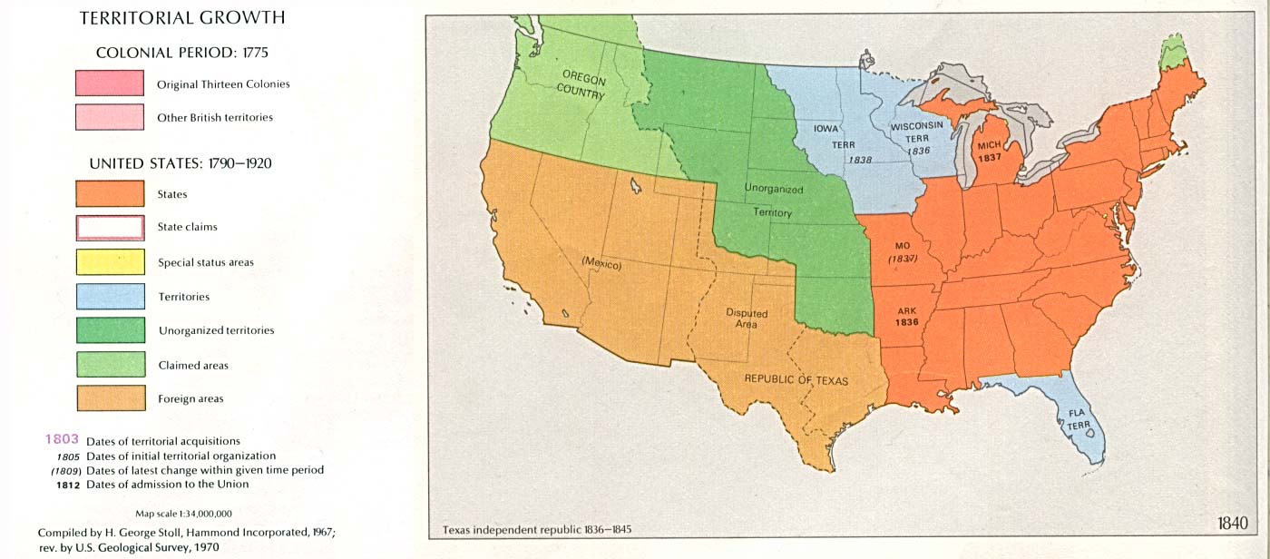
1809/ February 3 thru 1818 – Illinois Territory organized from IndianaTerritory, consisting of Wisconsin, Illinois and Northeast Minnesota. Indianaand Upper Michigan remaining in Indiana Territory. See map
Note: The Northwest Territory, after1816, was basically under the control and influence of the AmericanFur Company, owned by American millionaire John Jacob Aster, and acouple of Canadian firms. The company put one to two fur traders in charge,each with his own independent, but sometimes over-lapping area. This action waslegitimized by the U.S. government, but hardly publicized in history. Thecompany controlled almost all aspects of living within the Territory.
1818 – Wisconsin was again transferred back toMichigan Territory after Illinois became a state on April 18, 1818, and remained a part ofMichigan Territory until 1836. The area in Wisconsin was called Brown County On October 26th (16th ?), 1818 Brown County was formed by the Governor of theTerritory of Michigan – Lewis Cass, who named it after General Jacob Brown ( commandinggeneral of the US Army from 1815-1828), the county seat being in Green Bay. While still a part of Michigan Territory, namesapplied to the future Wisconsin area included “Ouisconsin Territory”and a revival of the name “Northwest Territory”.
1818 – Treaty with Great Britain sets Northernborder at 49 degrees North, adding Northwest Minn. to the MissouriTerritory.
1819 – A census of the Indians taken in 1819showed that there were 4800 in the Green Bay Agency. Governor Cassvisiting the western posts arrived at Green Bay to find over sixty dwellings andfive hundred inhabitants. The fort (Fort Howard) consisted of logbarracks facing three sides of a square parade ground, surrounded by astockade of timber thirty feet high, whitewashed, and garrisoned by threehundred men, under Captain William Whistler. Also stationed three milesabove Fort Howard were three hundred infantry. The boundaries of BrownCounty at this time stretched over the entire eastern shore of Wisconsin, to theeast to lake Michigan, to the south as far as the Illinois line, and as far westas the Wisconsin River and Fort Winnebago.
1820 – Missouri Compromise forbids slavery inwhat was to become theWisconsin Territory.
The first white settler, in what was to be latercalled the Town of Brookfield, William Howe, arrived in 1820 with a PresidentialLand Grant giving him title to the area.
As described by the historian, WilliamRaney, the region that is now Wisconsin, although a part of the United Statessince 1783 and of the Michigan Territory since 1818, belonged to another nation:”Apart from small bits of land used as the sites of FortsHoward and Crawford, and what had been occupied by French Canadian settlers longbefore and secured to them by European treaties, Wisconsin was in 1827 stilllegally the property of the Indians.”
In 1783, the United States and the Indiannations in the region paid little attention to each other. As early as the Warof 1812, however, this relationship began to change:
The United States government dealt only with those Indian tribes near enough to the settlements to cause trouble or impede the advance of the white frontier. During the generation between the War of 1812 and the Mexican War, Wisconsin was in the zone of contact between the two races. The federal government exercised control partly military and partly civil. An irregular line of garrisoned forts, established at various times, swept across Wisconsin and Iowa to the Missouri River and back across Arkansas and Louisiana. Along this frontier of some fifteen hundred miles a part of the regular army maintained peace and respect for the United States. Fort Howard at Green Bay and Fort Crawford at Prairie du Chien were established in 1816, and Fort Winnebago was added at Portage in 1828. Each of these forts usually had between one and two hundred soldiers.
Boundaries between tribal lands were notwell defined. Tribes traditionally crossed and hunted each others areas,occasionally leading to conflicts. A conference was held in 1825 at Prairie duChien, hosted by Lewis Cass and William Clark, precisely to quell disputes amongthe tribes and to set limits to their lands. “Thesoutheastern and southwestern corners of present Wisconsin with adjacent partsof Illinois were assigned to certain Chippewa, Ottawa and Potawatomi. The restof southern Wisconsin was recognized as belonging to the Winnebago, whoseirregularly shaped holdings touched the Mississippi north of Prairie du Chienand stretched northeast to Lake Winnebago and north to the Black River.”
1827 – Mineral Point was foundedin 1827 and was recognized as the political and economic center of the new(later) Wisconsin Territory. It was the seat of
1830 CENSUS INDEX lists the area as the MichiganTerritory, Iowa County (now Wisconsin).

After the Black Hawk War, two treaties weresigned. In September, 1832, the Winnebago signed away the remainder of theirlands south of the Fox and Wisconsin. A year later, the Chippewa, Ottawa, andPotawatomi relinquished the rest of southern Wisconsin east of the Rock Riverand adjoining Illinois. With the conclusion of those two treaties, all ofWisconsin south of the Fox and Wisconsin belonged to the United States.
Wasting little time, contracts were letimmediately by the federal government to survey the lands that had been ceded bythe Indians, and by the end of 1833 a significant part of the survey ofsoutheastern Wisconsin had been completed. By an Act of Congress approved onJune 26, 1834, two new land districts were created. East of a line from thenorthern boundary of Illinois to the Wisconsin River between ranges 8 and 9 wasthe Green Bay Land district; west of it was the Wisconsin Land district. Most ofsoutheastern Wisconsin thus became available to settlers and land speculators.For the land in the Green Bay district, notice went out that all surveyed landswere for sale by the government of the United States, the sale to take place in1835.
1834 – Lands East of the Missouri River in theMissouri Territory are transferred to the Michigan Territory. (Central/East N.Dakota and S. Dakota, Iowa and Western half of Minnesota.)
1834 – 1836 Spring – Topographic Bureau surveyingcrews set section corners and quarter section corners in the public lands inpreparation for the first public land sale.
The Michigan Territorial Legislature approved thecreation of Milwaukee Territorial County on 6 September 1834. Milwaukee County wasone of the four original counties in what later became the state of Wisconsin.Milwaukee, Green Bay and Mineral Point (Also called Wisconsin) were considered”land districts”. La Crosse is also mentioned as one as well.
1835 March – The Green Bay Indian Trail issurveyed from Illinois State Line to Fort Howard by the U.S. Army Corps ofTopographical Engineers.

Map 5 (JPEG, 165K): “The Entire Territory of Wisconsin. As Established by Act of Congress. April 10, 1836.” This map is an inset in a larger map which shows the populated areas of Wisconsin and Iowa Territories in 1838 available as a reprint from Wisconsin Trails Magazine. Click here for a larger version (JPEG, 578K) of Map 5. Carver’s Tract is shown in better detail here (JPEG, 99K). Source: John L’s Old Maps Part 1: c.1710-1854 A collection of images centering eventually (in Part 2) on Northwestern Wisconsin, particularly Sawyer and Washburn Counties.
Formed by an act of the Michigan Legislature, theWisconsin Territory was organized on January 1, 1836. At the time thatWisconsin became a Territory, Brown County lost that portion of her originalpossession north of the Menominee River and gained the remainder of the easternpeninsula. By Territorial Act on December 7th, 1836, Portage, Marquette,Calumet, Fond du Lac, Manitowoc, Sheboygan and portions of Washington and DodgeCounties were set off. (See BrownCounty 1800’s history) Another map of WisconsinTerritory
To Thomas S. Redford, probably, belongs thedistinction of having been the first one to drive his stake in this town ofLisbon (Did the name “Lisbon” exist at this time? If it did, why wasit named as such?).When he first came here, he accompanied the surveying party of Hudson, Vliet andBrink, who surveyed through the town early in 1836. In May of this year, he collated the claim which he now occupies, on Section 25.
1836/July 3 – Wisconsin Territory was erected byact of Congress approved April 20, 1836; but it was the fourth of July beforethe Territorial officers were sworn in, and the twenty-fifth of October beforethe meeting of the Territorial legislature (at Belmont, in what is now LaFayette county).
1836 – the Wisconsin Territory is formed and theMilwaukee County Territory within it (from Brown County). On 7 December 1836, the WisconsinTerritorial Legislature detached from Milwaukee County lands that became Dane,Dodge, Green, Jefferson, Portage, Walworth, and Washington Counties.
1838 – Iowa Territory created from WisconsinTerritory. Consists of the area “East of the Missouri River”(Central/East N. Dakota and S. Dakota, Iowa and Western half of Minnesota).Eastern Minn. remains part of Wisconsin Territory.
1838 – the Town of Lisbon is formed within the Milwaukee CountyTerritory along with the Towns of Summit to the west), Muskego (tothe southwest), and Mukwonago (to the south) (Note: The “town”referred to was in reality an election precinct or political unit, set by thelegislature.)
The Town of Lisbon (Township 8, Range219,East) had a population of 18 male head of households, family members totally 84.(Note: The 1837 Wisconsin Territory Census lists doesn’t list a Town ofLisbon, rather it is considered the Milwaukee Township in Jefferson County.)
1839/December 20 – Milwaukee County was dividedinto townships – the original Town of Lisbon (which was 12miles by 12 miles square) is split into the towns (each 6 miles by 6 milessquare) ofLisbon, Menomonee, Pewaukee and Brookfield (Pewaukeeactually split from Brookfield in 1840). This was approved by the Wisconsin TerritoryLegislature, but not effectiveuntil after March 1, 1840. Each of the other three original Towns (see1838) divided themselves up in like manner, but all still part ofMilwaukee County. See 1846.
The Town of Warren (later called Merton) wascreated in 1839 by the original Town of Summit split.
1840’s – The area is still rather wild, some Menomoneetribe of Indians, with a few Chippewa, remained in the marshy lakeland known as the “Wild Marsh” which was located betweenFussville and Lannon.
1840 – the Town of Menomonee (Township 8, Range 20,East) had a population of 59.
1841 – Territorial Legislature passes enablinglegislation which permits establishment of local Town government upon petitionof residents
1843 – The Town of Warren (Merton) wasdivided, creating the Town of Nehmabin (later called the Town of Delafield),. atthe First Town meeting held April 4, 1843 at the house of William Le Roy,on Section 26.
1844 – Sixteen towns now exist in what is tobecome Waukesha County.
1846/January 31 – the Towns of Lisbon, Menomonee,and Merton become part of the newlycreated Waukesha Countywhen the 16 western most towns split from Milwaukee County (which prior toDecember 7, 1836 had extendedall the way from Milwaukee to Madison) by Territorial Legislature vote.
1846, June 13 – By County Board vote,Prairieville (today’s City of Waukesha) becomes the Waukesha County Seat and aCounty Courthouse building is soon constructed (but not until the first attemptis torn down due to insufficient foundation support). The two-story domedbuilding is completed in 1849 and the County Board moves in.
The 1846 Enabling Act approves Wisconsin’sstatehood vote
1848/May 29 – Wisconsin became the 30th stateadmitted to the Union. The “Badger State” was the last state formed inits entirety from the Northwest Territory.
1848/1849/Winter of – The name of the Town ofWarren changed to Merton to correspond with the name of the post officeestablished in the town during the previous year.
More information on the Wisconsin Territory canbe found in the book:
History of the Territory of Wisconsin From18361848 Moses M. Strong A. M. The author takes an in-depth look atthe history of Wisconsin starting in the 1600s through 1848. From the firstvisit to Wisconsin by Nicollet in the 1600s through its induction into theUnited States of America, this book gives insight as to what life was like andthe history behind what made the state of Wisconsin what it is today. Thechapters include: Early Explorations of Florida and Louisiana,1512-1719 (includes early Wisconsin explorers); Wars with Fox Indians, 1712 to1746; The Langlade Family, 1745 to 1800; Jonathan Carvers Explorations, 1766 and1767; Progress of Settlements in the Northwest and transfer to BritishJurisdiction, 1705 to 1775; Under American Jurisdiction, 1787 to 1820; GreenBay, 1634 to 1836; Prairie Du Chien, 1680 to 1830; Chequamegon-Portage-Milwaukee;New York Indians, 1820 to 1839; The Lead Mines and Winnebago War, 1822 to 1828;The Black Hawk War, 1831 and 1832; Civil Government, 1512 to 1834; Legislationprevious to 1835; Wisconsin in a Transition State, 1835 to 1836; Organization ofWisconsin Territory; Territory of Wisconsin, 1836, 1837, 1838, 1839, 1840, 1841,1842, 1843, 1844, 1845, 1846, 1847, 1848; and Milwaukee and Rock River Canal. Afullname index is included. (1885) reprint, 655 pp., new fullname index.
In Wisconsin, the local units of governmentare the counties, towns, villages, cities, school districts, and specialdistricts. The 72 counties in Wisconsin are governed by a board of supervisorsand have many “home rule” powers. The cities and villages areincorporated, and also have “home rule” powers. An isolated villagemust have at least 150 persons for incorporation. A metropolitan village musthave 2,500 persons for incorporation. A village of more than 1,000 persons maybecome a fourth class city. Wisconsin has four classes of cities based onpopulation, but only Milwaukee is a first class city (more than 150,000persons). The form of government for cities and villages may be mayor-council,council-manager, or commission, although none of the latter are currently inuse. Towns (known as townships in most of the United States) consist of allareas not in incorporated cities or villages.
Further information can be found in Origin and LegislativeHistory of County Boundaries in Wisconsin (Madison, Wisconsin: WisconsinHistorical Records Survey, 1942), and “Local Government in Wisconsin,”State of Wisconsin Blue Book 1979-1980 (Madison, Wisconsin: WisconsinLegislative Reference Bureau: 1979): 95-310